Wysilab ships Instant Terra 1.15
Originally posted on 26 May 2018. Scroll down for news of the 1.15 update.
Wysilab has released Instant Terra 1.1, the first update to the 3D landscape generation tool since its release, adding new noise-based generators, support for colour maps, and new options for generating masks.
A fast, lightweight procedural tool for generating terrains for real-time work
Released earlier this year, Instant Terra is designed as a fast, lightweight tool for creating terrain, particularly for real-time work.
The development team comes from a background in game development itself, with CEO Alexis Vaisse having been lead programmer on Ubisoft’s in-house physics and cloth-simulation systems.
Workflow is primarily graph-based – the initial release included over 50 separate nodes, including a hydraulic erosion system – with the option to paint masks to control the effect of nodes.
The software imports DEM data or source images, and exports terrain as an FBX mesh or heightmap, supporting a range of common 2D image formats including OpenEXR.
Users work directly at the final resolution of a terrain, with changes displayed in a 3D preview in real time.
New in 1.1: new Perlin noise-based generators, support for colour maps, new masking options
To that, Instant Terra 1.1 adds two new terrain generators, Ridged Noise and Billowy Noise, both based on the Perlin noise algorithm, and intended to produce hills and ridge crests.
Users can also now work with colour maps on terrain – blending two terrains also blends their surface colour – and generate masks automatically from the orientation or curvature of a terrain.
There are also new Min and Max nodes, which take the minimum or maximum values of input terrains; and the option to create a mask by comparing the elevation of two input terrains.
Updated 2 September 2018: Wysilab has released Instant Terra 1.2. The new update introduces an experimental new rock erosion system, still officially in beta.
The new node simulates the movement of sediment due to gravity: a geological process referred to as thermal erosion, thermal shock, material slippage or talus deposition.
The hydraulic erosion system gets an update, with new presets for common types of weathering, plus the option to export the flow map generated by the simulation as a mask.
There is also a new set of Calculation nodes designed to perform basic mathematical operations; and new nodes to multiply masks or adjust their minimum and maximum values.
New output options include the ability to export normal maps in TIFF, PNG, TGA or BMP format, and to export as tiles when working with large terrains.
Workflow improvements include the option to create and colour code groups of nodes to keep a graph organised, and a new automatic backup system.
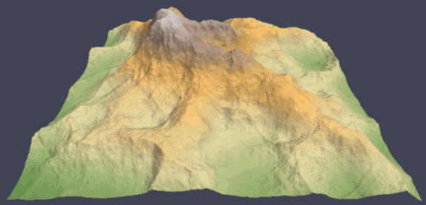
Updated 4 December 2018: Wysilab has released Instant Terra 1.3. The update introduces the option to generate terrain from any imported 3D mesh, as shown in the image above.
Import speed has also increased, probably quite significantly. Wysilab’s test case shows a 16GB import completing over 30 times faster: in 6.4 seconds, as opposed to 201.3 seconds in the previous release.
Workflow improvements include a new Graph explorer panel that displays all of the nodes used in a scene. Nodes can be dragged and dropped from the explorer to the node graph itself.
Updated 13 February 2019: Wysilab has released Instant Terra 1.4.
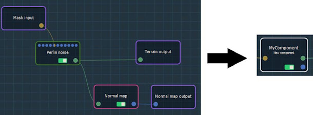
The update adds a single feature, although it’s a fairly significant one for workflow: sub-sections of the graph can now be collapsed into new ‘component’ nodes, and exported for reuse in other scenes.
Updated 5 March 2019: Readymade components can now be downloaded from Wysilab’s online library.
At the time of posting, four are available, including tools for transferring detail from one terrain to another, a split view for comparing terrains side by side, and utility tools for working with masks.
Updated 6 April 2019: Wysilab has released Instant Terra 1.5.
New features include a mountain erosion node. It simulates the effect of rock weathering over time, and produces more uniform slopes and less sedimentation than the existing hydraulic erosion node.
Other changes include the option to adjust the sun and ambient light when viewing a terrain, and the option to export 3D terrain in OBJ format, and masks in F32 RAW format.
Updated 2 July 2019: Wysilab has released Instant Terra 1.6.
The release introduces new water properties – water level, colour and transparency – and makes it possible to toggle the display of water in a terrain on or off.
The update also removes the maximum size limit on colour maps, makes it possible split the RGB channels of a colour map into separate masks, and makes it possible to export colour or normal maps as a set of tiles.
Other changes include a new contextual ‘fast creation’ menu, new Crop Terrain and Crop Mask nodes, support for UVs on exported meshes, and the option to export meshes in Alembic format.
Updated 30 October 2019: Wysilab has released Instant Terra 1.7.
The update overhauls the erosion simulation system, adding a new system for smoothing terrain through sediment deposition, and the option to generate flow maps to mimic the flow of water over the terrain.
It is also now possible to combine the effects of multiple erosion types in a single terrain, including the existing hydraulic, rock and mountain erosion effects, via a new Multierosions add-on.
Workflow improvements include a C++ API for live-linking Instant Terra to a game engine, making it possible to see updates to a terrain in-game in real time. It’s only available in the Pro edition.
Other changes include the option to duplicate nodes in the software’s node graph, or insert them into existing links; and a new Multiply node for multiplying input terrains.
Updated 13 December 2019: Wysilab has released Instant Terra 1.8.
The update adds the option to run Python scripts inside the software, accessed via a new custom node type in the scene graph, and to create what Wysilab describes as ‘GPU scripts‘.
There is also a new Swirl distortion effect and a new gamma correction node.
Updated 4 February 2020: Wysilab has released Instant Terra 1.9.
Building on the Swirl node in the previous update, the release adds three new Warp nodes for distorting terrain based on input vectors or masks.
Other new features include an Equalizer for setting the relative strengths of different frequency details in Noise effects; and a new file name parameter for specifying custom inputs and outputs from nodes.
Updated 12 March 2020: Wysilab has released Instant Terra 1.10.
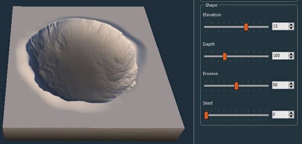
The release adds a stamping system, making it possible to replicate features across terrain in a user-customisable distribution; and a new crater generator node.
There are also new blending modes for terrains and masks, plus the option to set black and white thresholds for masks, and the option to tile colour maps.
Updated 27 April 2020: Wysilab has released Instant Terra 1.11.
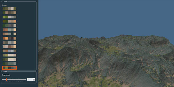
The update adds new tools for texturing terrains, including a new Colorize node that can be used to apply one of 15 preset colour themes, or the option to apply a custom theme.
In addition, the Swirl, Warp, Directional Warp and Vector Warp nodes can now be used to deform colour maps as well as terrain itself.
New terrain-generation features include a Terraced node for generating stepped terrain, and a Constant Value brush in the Painted Mask node for creating areas of constant elevation manually.
Updated 11 June 2020: Wysilab has released Instant Terra 1.12.
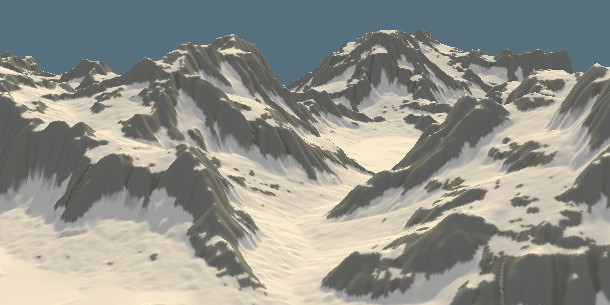
The release adds a new snow-generation system – both a “two-click” version and an Advanced Snow node – and a MultiBlend node, making it possible to blend an unlimited number of terrain layers or masks.
There are also a number of workflow improvements and options for processing terrain colour maps. Users of Instant Terra Pro get new Python callback hooks for pipeline integration.
Updated 8 July 2020: Wysilab has released Instant Terra 1.12.5.
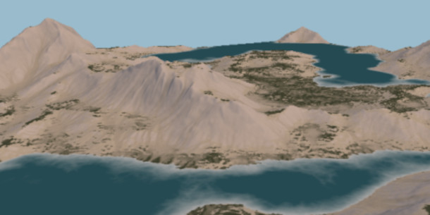
Although it isn’t a ‘full’ release – Wysilab describes it as “while waiting for … 1.13” – it adds new Water level and Advanced water level nodes, making it possible to add standing water to terrain.
Unlike the existing water level display, water can be generated at an altitude relative to the terrain, or at multiple altitude levels, making it possible to create lakes as well as oceans.
The result can be colorised to reflect the depth of the water, with 10 preset colour themes available.
Updated 25 September 2020: Wysilab has released Instant Terra 1.13.
The update adds a new World Browser that connects to the OpenTopography database, making it possible to download elevation data for any region of the world and generate a corresponding terrain.
A new Colorize satellite map node helps to create quick colorised renders of the result.
Other changes include the option to display isolines on terrain or place a mannequin in scenes for scale.
Updated 4 November 2020: Wysilab has released Instant Terra 1.14.
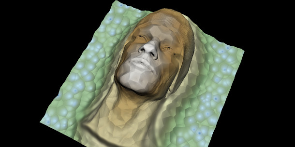
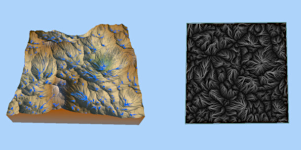
The update adds support for pen pressure when painting masks on a graphics tablet; a paths generator, intended for positioning rivers on flat terrain; and a Soften node (shown above), for smoothing terrains.
Several of the the features added in version 1.13 have also been updated, with the World Browser now being complemented by an Upscaling node, which automatically up-reses imported heightmaps.
Updated 16 December 2020: Wysilab has released Instant Terra 1.15.
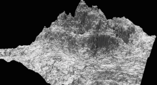
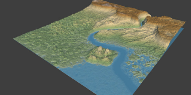
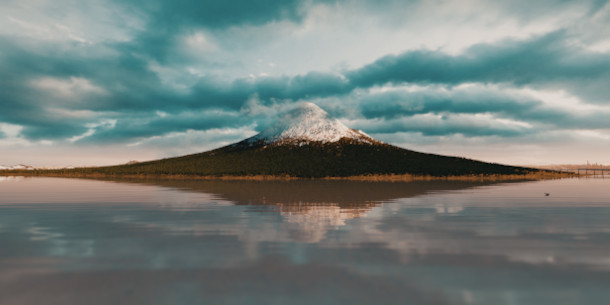
New features include the option to search for real-world locations directly in the World Browser by typing in their name or map co-ordinates: the render above shows the result of searching for ‘Mount Fuji’.
Other changes include the option to render high-resolution images directly from the viewport; new Sharpen and Ramp Colorize nodes for terrain; and auto-connection when adding new nodes to the node graph.
Pricing and system requirements
Instant Terra 1.15 is available now for Windows 7+ only.
The software was originally rental-only, but Wysilab has now switched to perpetual licences for users with revenues under $500k/year. They cost $149 for 8K export; $199 for unlimited resolution.
There is also a Pro edition aimed at larger studios, which includes features geared towards generating very large terrains, multi-file export, and a Python API. It is priced on enquiry.
Read a full list of new features in Instant Terra 1.15 in the online changelog