Agisoft releases Metashape
Agisoft has released version 1.5 of PhotoScan, its popular photogrammetry software, and renamed the product Metashape. The upgrade is free to existing PhotoScan users.
The update, which shipped last week after a few months in beta, introduces a new method of mesh generation from depth maps, increasing the speed at which detailed geometry can be generated.
Users of the Professional edition get a new AI-driven system for automatically classifying aerial reconstructions by land use type, plus support for cloud processing.
A new product name – but still essentially PhotoScan 1.5
Despite the new features, the most obvious difference in version 1.5 of the software is the product name.
The change reflects its expanding feature set: while the Standard edition – the version most users in the entertainment industry will be familar with – is still primarily aimed at people who want to generate 3D scans of people or objects from reference photos, the Professional edition is targeted more towards land surveys.
According to Agisoft, Metashape “inherits all the professional photogrammetric kit features from PhotoScan and offers some more to enrich your experience into the space of intelligent photogrammetry”.
However, it seems fair to think of it as the latest version of PhotoScan, rather than a separate successor product: Agisoft’s forum announcement describes the update as “free and smooth as usual”.
New in the Standard edition: generate detailed 3D models based on depth maps
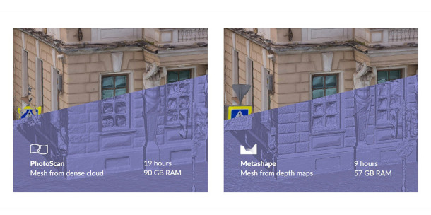
For users of the Standard edition, the main new feature in Metashape is a new mode for generating highly detailed 3D models based on depth maps.
Agisoft’s online documentation shows a 3D model of a building being generated from 730 images in 9 hours in Metashape, as opposed to 19 hours in PhotoScan, and at a noticeably higher level of detail.
Other than that, it’s mainly performance and workflow improvements, although users can also now export models in glTF or X3D format, for use in online or real-time applications.
New in the Professional edition: AI-driven land use classification, cloud processing
Users of the Professional edition also get a new option for automatically classifying dense point cloud data generated from aerial photos by land use type: buildings, roads, vegetation and so on.
The system is based on machine-learning techniques, and Agisoft says that the quality of the results will improve over time as users submit real-world data.
The software can also now process large datasets in the cloud – users can actually buy cloud computing time from directly within the software – as well as on a local machine or render network.
Pricing and system requirements
Metashape is available for Windows XP+, Debian/Ubuntu Linux with glibc 2.13+ or Mac OS X 10.8+. The Standard edition costs $179 for a node-locked licence; the Professional edition costs $3,499.
Read an overview of the new features in Metashape
(You can find the full changelog here)